DIVA – Demonstration of an Integrated approach for the Validation and exploitation of Atmospheric missions
ESA/ESRIN contract 4000121773/17/I-EF
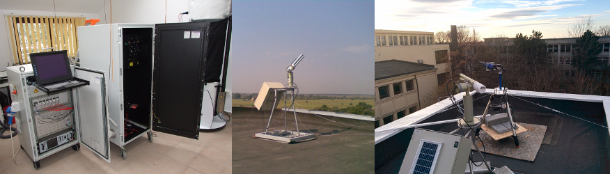
DIVA is setting-up of a pilot hub to collect, handle, archive, and exploit in a synergetic way observational data, as provided by the future integrated atmospheric composition ground-based network infrastructure, for the validation of ESA and Copernicus missions.
Purpose
Current advances in atmospheric composition measurements from space require access to independent, high-quality, global atmospheric composition ground-based data for the validation of the upcoming European EO missions and payloads S3, S5p, ADM-Aeolus, EarthCARE, S4, S5, MERLIN, GOME-2c, 3MI. To address the societal benefits and scientific objectives set forth by the missions, the downstream services and GEOSS, coordinated development of synergistic ground-based measurements techniques and algorithms are needed.
Consortium
 National Institute of Research and Development for Optoelectronics (INOE) is involved in fundamental and applicative research in optoelectronics, analytical chemistry, and high pressure physics. During the last decade the Remote Sensing Department developed a state-of-the-art research infrastructure for atmospheric studies, which coordinates the Romanian Atmospheric 3D research Observatory and is part of international research networks (EARLINET, AERONET, MWRNET) contributing to the joint European climatological database. During the last years, the department have been involved in several ESA contracts dealing with algorithm and technologies development, as well as participation to calibration/validations activities.
CNRS Délégation Régionale Nord-Pas de Calais et Picardie (LOA) is expert in radiative transfer in the atmosphere and aerosol/cloud remote sensing. It also has developed a strong expertise in instrumentation at ground-based level with CIMEL photometer and AERONET network (LOA-CNRS/GSFC-NASA project) and satellite (PARASOL, POLDER space missions). Thanks to the expertise in photometer and radiometry, the group PHOTONS, national service for aerosol observation including a calibration centre, has been developed at LOA and it is now well recognized at international (AERONET Federation) and European level (AERONET Europe within ACTRIS project).
![]() LuftBlick is an internationally operating science and engineering company that specializes in atmospheric remote sensing in the ultraviolet, visible and near-infrared, with data management and instrument hosting. Our expertise includes design of ground-based and satellite-instrumentation, development of instrument control software, laboratory and field calibration, retrieval algorithms for atmospheric trace gases (e.g. O3, NO2), instrument network hosting, operational network data and image processing, satellite validation support, data search and collocation, data harmonization, quality control, analysis and conversion.
LuftBlick is an internationally operating science and engineering company that specializes in atmospheric remote sensing in the ultraviolet, visible and near-infrared, with data management and instrument hosting. Our expertise includes design of ground-based and satellite-instrumentation, development of instrument control software, laboratory and field calibration, retrieval algorithms for atmospheric trace gases (e.g. O3, NO2), instrument network hosting, operational network data and image processing, satellite validation support, data search and collocation, data harmonization, quality control, analysis and conversion.
Generalized Retrieval of Atmosphere and Surface Properties (GRASP-SAS) is an entity created by the efforts of Dr. Oleg Dubovik to valorize the scientific achievements of LOA/University of Lille-1 in developments of remote sensing algorithms. The company was founded in February 2015 and it is headed by Dr. Benjamin Torres in close cooperation with LOA/University of Lille-1 that is involved in Earth Science research for more than 50 years. Since the creating, GRASP has been involved in several projects from ESA, EUMESAT, and other private companies. GRASP is in contact with the largest space agencies in the world with the goal to improve the human knowledge about the atmosphere and surface properties which has an important and probed impact in human activities. GRASP SAS is to be provided by CNRS and University Lille-1 with the rights to support and distribute GRASP algorithm originally developed by LOA.
Catalysts GmbH was founded in 2007 and has grown to over 150 employees distributed over offices in Hagenberg/Austria, Linz/Austria, Vienna/Austria, and Cluj/Romania. Catalysts develops individual software solutions for industry, agencies, and the public sector focusing on Big Data and Machine Learning, High Performance Computing, and Large-Scale Agile Projects. Catalysts has built software solutions for industrial companies, agencies, and the public sector. In previous projects with ESA, the GRASP algorithm has been optimized, support for additional instruments was added, and large re-processings were conducted. As part of the Thematic Exploitation Platform programme, Catalysts is participating in the coastal domain, taking care of the system integration and pre-ops maintenance. In several nationally funded projects, Catalysts has provided the initial infrastructure setup for the EODC, contributed its own IT infrastructure, and implemented software services in the domain of wetland monitoring, crop monitoring, forestry and high resolution imagery.